Friday, May 3, 2013

Ch. 17 Hawaii and the Pacific Islands


vs.


Oh how I wish growing up in The Central Valley could be only just a smidgen similar to that of Hawaii and the Pacific Islands. Their beauties do not compare. Although it is often displayed as a paradise, Hawaii's natural environment has a nasty side. There are volcanoes, tsunamis, earthquakes, cold frosts, gusty winds, intense rainfall, and occasionally waterspouts. The Central Valley does not experience such vast amounts of weather severity. 

The volcanic soils and mild climate of Hawaii supported a healthy harvest of tropical crops, especially sugar cane and pineapples. The Central Valley dominates the agricultural industry of the United States but it does not produce coffee. The Kona Coffee Belt is part of the United States; only coffee-producing region. Other tropical crops include macadamia nuts, papaya fruits, and lei flowers. 

The two regions have very few similarities. The Central Valley does not support a booming tourism economy like the Hawaiian and Pacific Islands. Because of it's isolation, the islands are forced to import most of their commodities. Most likely crops from California's Central Valley!

Ch. 16 The Pacific Northwest


Most of the Pacific Northwest's economic history has been involved in reaping the land of it's resources like lumbering and fishing, but recently high technology and the tourism industry have become vastly more important. Both of which are opposite to the ideals of the Central Valley. The central valley reaps the bountiful harvests, then easily replaces it for next seasons picks. It is quite difficult to replace a tree after it has been cut down. 

While the Central Valley is more focused on agriculture to boost it's economy, powerhouse industries such as Starbucks Coffee and Microsoft dominate these economic activities. Internationally know to be associated with Seattle, Amazon and Boeing proudly boast there home there in the state of Washington. 


A study of 65 rural California towns indicates that labor-intensive agriculture contributes to poverty and welfare demands in rural communities by attracting large numbers of unskilled foreign workers and offering most of them poverty-level wages. In the 65 towns, 28% of the residents live in households with below-poverty incomes. Major policy choices for ameliorating this situation include modifying immigration and labor laws that affect farming to help farm workers earn higher wages. The Pacific Northwest's economic strength and diversity, high incomes, scenic amenities, and high quality of life differs from the life seen for many people in California's Central Valley and it has been one of the fastest growing regions of North America for the past 60 years. 


Click Here to go to "The Appalachia of the West" article from The Economist


Ch. 15 California


The Central Valley is smack dab in the center of the namesake of this chapter, California. California can be split up into three large areas: mountains that parallel the coast, interior valleys, and higher mountain ranges in the east. 

California is famous for the Gold Rush in 1849, and the Central Valley hosts the town of Coarsegold. The place was first called Texas Flat after miners from Texas discovered gold there in 1849. The current name derives from the California Gold Rush of the mid-19th century, when prospectors discovered coarse lumps of gold in a nearby creek. At one time, several dozen gold mines operated in the area.

The Picayune Rancheria of Chukchansi Indians, a federally recognized tribe, is headquartered in Coarsegold. In June 2000, the Picayune Rancheria Tribe of Chukchansi Indians announced plans of constructing a resort casino close to Yosemite National Park. The casino opened on June 25, 2003, while the resort opened on August 22, 2003.


Ch. 14 MexAmerica

The Central Valley's population demographic is very similar to that of MexAmerica. The agricultural industry offers bountiful amounts of jobs for laborers. 

Most of MexAmerica lacks natural resources that could support a bountiful agricultural industry.  It also includes a great deal of dry, rugged terrain that is poorly suited for agriculture. 

Areas in this region are so dry they include deserts. Although the Central Valley is hot and dry they do not compare to these areas. The driest place in North America resides in MexAmerica. Death Valley, California experiences three inches of rainfall per year. "Other places such as the Mojave Desert in Southeastern California, the Sonoran Desert of southern and central Arizona, and the Chihuahuan Desert of Eastern Arizona and New Mexico are nearly as dry (Hardwick)." Latinos make up the largest “minority” population in the Central Valley, 36.19 percent of residents identified as Latino or “Latino and White.”

Flash flooding is a major concern throughout the region of MexAmerica. While the Central Valley does not normally suffer from flash flooding, it was subject to disaster during The Great Flood of 1862 that effected Oregon, California and Nevada. 


Ch. 13 The Intermontane West

The Central Valley of California, although close in proximity to The Intermontane West, do not share many similarities. The Intermontane West hosts dramatic scenery, colorful history, and natural wonders. While most people think the majority of the Central Valley is somewhat of an eyesore.....and terribly smelly. 

The major difference between the Intermontane West and the Central Valley is the major economic activity of tourism. The Central Valley does not boast tourism like the latter. 

Northwestern Wyoming is home to Yellowstone National Park, the world's first national park. Sun Valley, Idaho and Park City, Utah bring in thousands of winter sports enthusiasts to their world renowned ski resorts. Biggest of all, Nevada hosts the incredibly profitable cities of Reno and Las Vegas that boasts legal gambling, which got the state of Nevada out of crippling debt.

In both the Intermontane West and California's Central Valley they share the precious resource of water from The Colorado River. Both constantly fight over this hot commodity for vital reasons. This river gives life to many, as drinking water and irrigation water. 

Settlement of Native Americans and First Nations was prevalent in The Intermontane West. Which is similar to The Central Valley.


 There is not much to look at during your drives in the Central Valley. 

Ch. 12 The Rocky Mountain Region


The Rocky Mountain Region and California's Central Valley could not be more polar opposite. The topography is vastly different. The Rocky Mountains are characterized by it name: they have many "rocky mountains". While the Central Valley does as well, characterized by a long flat valley floor. 

The Rocky Mountain region's weather can turn ferocious and life-threatening in a moment's notice, and The Central Valley does not share that fact. This area often experiences snow, which makes it difficult to host bountiful harvests similar to the Central Valley. In fact, "much of the Rocky Mountain region is unsuitable for agriculture because most of it's terrain is rugged, steep, or arid. The Central Valley may see frost, but most of the time NEVER sees any snow.

Even though the two places seems vastly different, they both hosted many tribes of Native Americans. "The northern Rockies in Alberta, British Columbia, and northern Idaho and Montana were home to such tribes as the Kalispel, Coeur d;Alene, Flathead, Nez Perce, Kootenai, and Black Feet (Hardwick)." All tribes were skilled hunters. 

The Rocky Mountain region and the Central Valley are both experiencing rapid population growth. Unfortunately, with that comes traffic congestion, environmental degradation and urban sprawl. 

Ch. 11 The Great Plains


The Great Plains of America, consisting of 12 states and parts of three canadian provinces shares both similarities and differences with California's Central Valley.

The Central Valley lives in a constant booming economy in the agricultural industry. While The Great Plains unfortunately must deal with a boom-bust economy that is unreliable for the economy. Similarly to The Dust Bowl of the 1930's in The Great Plains, California's Central Valley commonly suffers from droughts. Both natural causes and man made problems make it difficult for farmers to acquire all the water they may need to support their crops.

Both the Central Valley and Great Plains once shared an abundant amount of bison in their grasslands. Sadly, in most places these populations have declined. "Biologists estimate that as many as 60 to 80 million bison inhabited The Great Plains before 1800, but during the 19th century they were nearly exterminated. Their hides were made into leather and their bones became fertilizer. Only about 100 remained alive by 1900, and all of these survivors lived in Yellowstone National Park." In The Central Valley the extinction of their entire megafauna has been due to their depletion of natural wetlands and grasslands and fire. "Early reports from explorers indicate that vast herds of grazing animals in the Central Valley rivaled the numbers of bison on the Great Plains(source here)."

Many young people have been leaving The Great Plains, leaving the area to experience population loss in recent years.  The opportunities in urban and suburban areas have been a pull factor for those leaving. Unlike The Great Plains, about 6.5 million people live in the Central Valley today, and it is the fastest growing region in California.  


Thursday, March 7, 2013

Ch. 10 The Coastal South

California's Central Valley does not attract as many tourists, has no resorts, and I am unsure why anyone would want to retire there in comparison to the Coastal South. 

Petroleum and natural gas is found in great quantities in the Coastal South, but "sizable oil and natural gas deposits are found across six geological basins in California, located primarily in the Central Valley and along the Pacific coast (seekingalpha.com)."

"Researchers estimate reserves of between 150 million and 250 million barrels of oil and gas. The Kern County discovery has received the most press, but experts estimate there are at least six fields in the region that contain reserves exceeding 100 million barrels of oil (alphadog.com)."

Kern River Oil Field; view from Panorama Park in Bakersfield, on the blufftop across the river.


The Coastal South and the Central Valley do not share similarities within climate. Rarely does the Central Valley get humid, and that's a staple within the Coastal South's climate change. 

Although the soil in the Coastal South is usually infertile, they still produce large portions of certain crops. 

      Most notably:

  • Citrus fruit- oranges, grapefruit, tangerines, lemons, and limes. 
  • Sugar cane
  • Rice

These crops tolerate little to no frost. 

Ch. 9 The Inland South

Farming was once a vital resource to the economy of the Inland South. Sadly, it dropped substantially within the 20th century. Like California's Central Valley, the Inland South focused on commercial production for export.

The Inland South struggled with slavery. Although California was admitted into the Union as a free state, it still toiled with its bouts of slavery.  Plus, slavery was in effect under Mexican Law and popular with the Spaniards that previously owned the land. 

Many slaves came to areas of the Northern Central Valley with their Southern slaveholders during the Gold Rush. They would often earn enough to take back home and buy out their family from slavery. 


Allensworth, California in Tulare County is a town founded in 1908, with the idea that African Americans could own property, learn, thrive, and live the American Dream. The town was named by Lt. Colonel Allen Allensworth who was born into slavery and later became a chaplain of the United States Army. 

Lt. Colonel Allen Allensworth


Allensworth, Ca


The Inland South contains very diverse states such as Texas. Only California rivals Texas for it's diversity of people, places, and natural environments. 

Ch. 8 The Great Lakes and Corn Belt


       vs.


The Great Lakes and Corn Belt region of the United States share similarities  in their fruitful bounties of agriculture with California's Central Valley. While California is the most productive state in terms of agricultural receipts with 13.20% of total US production, Iowa is the third with 6.07% of total US production. Nebraska, Minnesota, Illinois, and Kansas follow immediately after in ranking.

The Great Lakes and Corn Belt region is situated in a vast ventral lowland between the Appalachian Mountain Province to the east and the Rocky Mountains to the west. Much like the Central Valley surrounded by the Sierra Nevada mountain range, Cascade Range and Klamath Mountains, the Coast Range, and Tehachapi Mountains. Both areas share similar landscapes that consist of gentle rolling hills.

Like California, in the Great Lakes and Corn Belt region, the more north you travel, the more extreme the winters will get.

The Central Valley does not compare to the historically profitable industrial sector of the Great Lakes and Corn Belt region. It has not shared the same level of success. Sadly, there has been a mass exodus of the steel mills that made this region equally as profitable as their agricultural production. This exodus has coined the term "Rust Belt" for parts of the region.

Ch. 7 Megalopolis


Sacramento Metropolitan Area


No city or metropolitan area in California's Central Valley can compete with the population numbers of that found in Megalopolis. The closest comparison is that of Baltimore- Towson, MD with 2,690,886 people in 2010 and the Sacramento Metropolitan Area of the Central Valley with a population of 2,461,780. 

"The Sacramento metropolitan area experienced a growth of nearly 20% in the last decade. The 2010 United States Census estimates for the region totaled a population of 2,461,780, making it the 4th largest metropolitan region in California and 18th largest in the United States (Wikipedia)."

The principle cities of the Sacramento Metropolitan Area are:
  • Sacramento
  • Arden-Arcade
  • Roseville
  • Yuba City
  • South Lake Tahoe
  • Truckee

California is the most populous state in America and therefore has the "largest number of representatives in the U.S. government, home of the California State Capitol and the secondary location of Supreme Court of California and was the original terminus for the First Transcontinental Railroad (Wikipedia)."  

Because of this, the tertiary sector is most dominant in this area. This is contrasting from the rest of the Central Valley that is heavily invested in the primary sector through agriculture. 


Ch. 5 The Atlantic Periphery


California's Central Valley differs greatly from the Atlantic Periphery. While the valley's Mediterranean climate and San Joaquin soil provides abundant agriculture, the Atlantic Periphery's cool climate and rocky soils provide unsuitable land for large-scale commercial agriculture.

The Atlantic Periphery is comprised of large forests and abundant quantities of offshore fish and other marine animals. The valley is home to vast plains and grasslands, with gentle rolling hills while being surrounded by mountains. "The Central Valley was once home to large populations of pronghorn antelope, elk including the endemic Tule Elk subspeciesmule deerCalifornia ground squirrelsgophers, mice, hare, rabbits and kangaroo rats, along with their predators including the San Joaquin Kit Fox which is now an endangered subspecies surviving on the hillsides of the San Joaquin Valley(Wikipedia)." 

"Although, there are some areas that produce specialty crops. For instance, Maine produces the majority of North America's blueberries. Cranberries are produced in Maine and Massachusetts. Maple and dairy products are exported from Vermont. In northern Maine and adjacent New Brunswick is an important potato producing region. In Canada, the Annapolis Valley of Nova Scotia is a well-known apple producing region (The Geography of North America, 97)." 

Without access to salt water, the valley is situated inland without swift access to oceans or ports. On the latter, the Atlantic Periphery has all of the advantages that come with living on a coast. With this easy access to trade, there was early settlement. 

Wednesday, March 6, 2013

Ch. 4 The North American Political Economy

Agriculture is the primary industry in most of the Central Valley, meaning the majority of workers are employed in the primary sector. 


"The Central Valley is one of the world's most productive agricultural regions and is the largest patch of Class 1 soil in the world. More than 230 crops are grown there. On less than 1 percent of the total farmland in the United States, the Central Valley produces 8 percent of the nation’s agricultural output by value: 17 billion USD in 2002. Its agricultural productivity relies on irrigation from both surface water diversions and groundwater pumping from wells. About one-sixth of the irrigated land in the U.S. is in the Central Valley (Wikipedia)."


"The top four counties in agricultural sales in the U.S. are in the Central Valley (2007 Data). They are Fresno County (#1 with $3.731 billion in sales), Tulare County (#2 with $3.335 billion), Kern County (#3 with $3.204), and Merced County (#4 with $2.330 billion (Wikipedia)."

 "A notable exception to the predominance of agriculture has been the Sacramento area, where the large and stable workforce of government employees helped steer the economy away from agriculture. Despite state hiring cutbacks and the closure of several military bases, Sacramento's economy has continued to expand and diversify and now more closely resembles that of the nearby San Francisco Bay Area (Wikipedia)."


 Sacramento Bridge 


Sacramento Capitol Building

Ch. 3 Historical Settlement of North America

The settlement of California's Central Valley began like many areas of the United States. Native Americans were the first inhabitants of this location. 

Most recently: 

  • Maidu Tribes, Central Sierra Nevada in the drainage area of the Feather and American Rivers
  • Interior Miwok Tribes, Sacramento Valley and the Sierra Mountains
  • Yokut Tribes, San Joaquin Valley stretching down into Bakersfield


     Location of Maidu                   Location of Miwok                                       

                                                                                                   
                          Location of Yokut


"The second largest concentration of Americans claiming Portuguese ancestry is in central California. Although Spanish and Mexican settlers did establish roots in California, it was mainly along the coast. Rarely did they venture the middle of the state where they would have found fertile soil perfect for settlement. The discovery of gold in the 1850's brought Portuguese settlers from the coastlines and into gold mining camps in the Sacramento Valley. Most of these early immigrants were Azoreans, who had come to California from southeastern New England(loc.gov)."

Portuguese settlement in the Central Valley increased at the end of the eighteenth century. These newcomers engaged primarily in agriculture, including dairying and intensive vegetable and fruit farming. Once they established themselves in the San Joaquin Valley, they developed fruit, vegetable, and dairy farms in San Joaquin, Stanislaus, Merced, Kings, and Tulare counties.

"Primary sources of population growth are people migrating from the San Francisco Bay Area seeking lower housing costs, as well as immigration from Asia, Central America, Mexico, Ukraine and the rest of the former Soviet Union(Wikipedia).The three major languages spoken now in the Central Valley are English, Spanish, and Hmong.

Tuesday, March 5, 2013

Ch. 2 North America's Environmental Setting

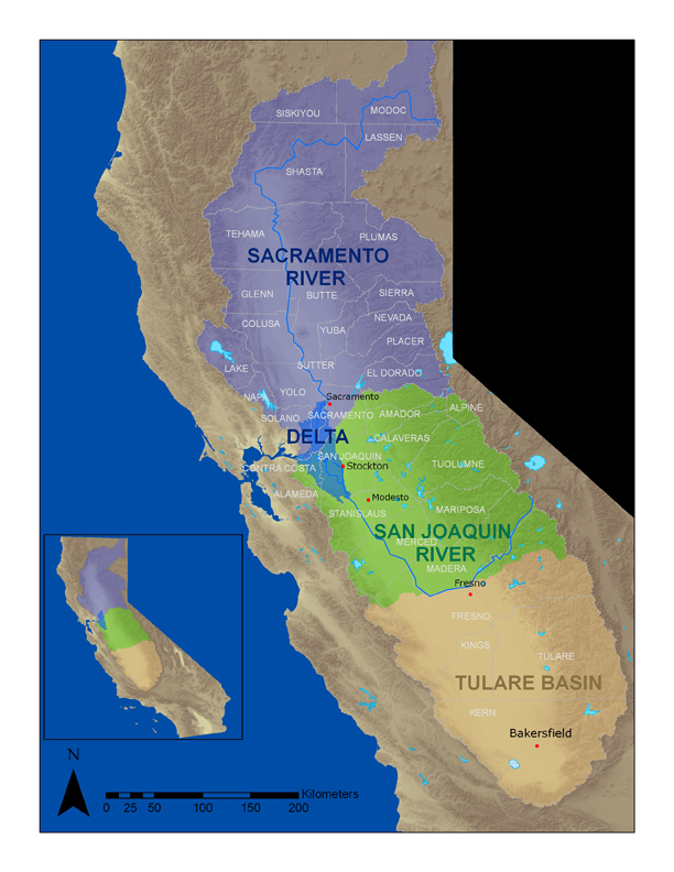
California's Central Valley is 450 miles long and 40-60 miles wide. 

It is bounded by the Sierra Nevada Mountain Range in the East, Cascade Range and Klamath Mountains in the North, Coast Range and San Francisco Bay to the West, and the Tehachapi Mountains to the South. 

"This vast interior valley was created over one hundred million years ago when huge masses of granite rose above the surface of the earth in California to form the core of the Sierra Nevada, and glaciers moved over the land, carving out channels in the mountains that became rivers----rivers that over time brought sediment to the valley (valleyhistory.org)."

The only exception to the flat land surfaces of the valley, is remnants of an extinct volcano named Sutter Buttes in Yuba City, just 44 miles north of Sacramento. 


Sutter Buttes in Yuba City, CA

There are two major river systems in the valley; the Sacramento River and the San Joaquin River, along with their tributaries. 

"The rivers of the Central Valley converge in the Sacramento-San Joaquin Delta, a complex network of marshy channels, distributaries and sloughs that wind around islands mainly used for agriculture. Here the freshwater of the rivers merges with tidewater, and eventually reach the Pacific Ocean after passing through Suisun Bay, San Pablo Bay, upper San Francisco Bay and finally the Golden Gate (Wikipedia)."


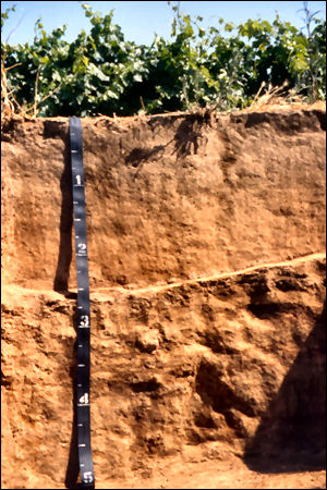
The soil in the central valley is the San Joaquin (soil) that has become the official designated state insignia. San Joaquin is the State Soil for California. "San Joaquin soils are classified in USDA soil taxonomy as fine, mixed, active, thermic abruptic durixeralfs.

  • Surface layer is brown loam.
  • Upper subsoil is brown loam, lower subsoil is brown clay.
  • Substratum is light brown and brown, indurated duripan with 70 to 90 percent silica-sesquioxide cementation (Wikpedia)."


While living in this region, the weather and I were constantly on opposite sides. The Northern Central Valley has a hot Mediterranean climate, while the Southern Central Valley is dry enough to be Mediterranean steppe or even low-latitude desert. It is characterized by hot and dry summers,with temperatures that can soar to 115 degrees Fahrenheit, and cool and damp winters. Mid-Autumn to mind-spring comprises the rainy season. Ground fog known as "tule fog" is very dangerous and common in the valley. "The northern half of the Central Valley receives greater precipitation than the semi desert southern half. Frost occurs at times in the winter months, but snow is extremely rare (Wikipedia)."

Ch. 1 Introduction


Hello, hi, and welcome to my very own blog about California's Central Valley for Geography 321OL. You may be asking yourself, "Why would anyone choose the Central Valley for their blog project?" When we think of California, attractions that pop into our head are obviously Hollywood and the Golden Gate Bridge, but the Central Valley is often overlooked. 

I spent my entire life living in the Central Valley and never once found beauty within it. To tell you the truth, I hated living there. With this project, I vow to create an appreciation for the land that raised me, and hopefully spark an interest in others to explore or at least think and know about California's Central Valley. 


Located smack dab in the middle of California, the Central Valley is surrounded by mountain ranges. 

The Central Valley is California's agricultural Heartland because of its long growing season and fertile soil. Because of this,  it has the largest single concentration of fruit and nut farms and vineyards in the United States. 


The Central Valley was seen by Spanish explorers in the 1500s but remained virtually uninhabited until the 1849 California gold rush.Now, about 6.5 million people live in the Central Valley, and it is the fastest growing region in all of California. "Primary sources of population growth are people migrating from the San Francisco Bay Area seeking lower housing costs, as well as immigration from Asia, Central America, Mexico, Ukraine and the rest of the former Soviet Union. (Wikipedia)" After English and Spanish, Hmong is the third most commonly spoken language.

Politically, the new residents of the Valley (as those who live there call it), many of whom were drawn to the area's cheaper housing, tend to be independent voters -- and that has turned this into one of California's only swing regions.